
We’ve been riding in the mountains on remote mountain-biking expeditions for two decades, wishing we had a way to track our routes. Our Suunto Vector “
At any point on the mountain, you’re able to Twitter or Facebook or text your friends, providing your exact location pegged to an online map. This is assuming cell service, which can be a big if. But even that is expanding every year.
We first considered the Garmin Edge 705, retailing at $595, a powerful and handy dedicated device. It has the advantages of being bike-specific, offering info like cadence, heart rate, riding time (separated from lunch, for example), elevation and even grade. And it can work with a variety of downloadable maps. But it can’t do real-time updates to the Web. Garmin is scrambling to leverage its brand name and user base with things like Garmin Connect, but in the age of Twitter and Facebook it may be a losing battle.
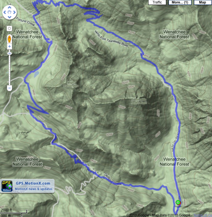
There’s a bunch of GPS apps out for the iPhone. We settled on the $2.99 MotionX-GPS and have been testing it in recent weeks. (A leading freebie, Google’s My Tracks, lacks the feature set and sparkling user interface of MotionX.)
Using MotionX is somewhat of a moveable feast. The app has upgraded three times in the past couple of months and keeps adding to its versatility. We’re still feeling our way but are impressed with the huge convenience factor.
It also helps to have a certifiable tech genius behind the product — Philippe Kahn, co-founder of Fullpower Technologies, which produces MotionX. We’ve known Philippe since his PC software days doing battle with Bill Gates, and he’s always light years ahead of the game.
With MotionX we can track real-time elevation gain, distance, time, elevation profile and instantly have the totals at the end of the ride. We can tweet or Facebook on the ride as well. A photo taken with the iPhone camera can be mapped and shared right from the trail.
There’s something spooky about all this, but at the same time, wow: I can provide as-I-ride updates of my progress to my always-worried spouse and next time simply send the route map to her for reference. Real-time depends on cell service of course, and that’s not always available on the big epics. But Galbraith has good coverage, so does Whistler and many of the lowland mtb haunts. Plus you can get cell service in unlikely and increasingly widespread places as the logging companies and the feds seek to communicate, as well as assist Homeland Security in keeping track of your and my every move.
That’s the wilderness tradeoff: Safety for privacy. Little Brother Is Watching You.
For a glimpse of where this is headed, check out Philippe’s in-the-middle-of-the-ocean video, in real time on the iPhone using satellite technology.
A couple of noteable caveats here: In a canopied forest, you can lose the GPS signal. In most cases we found MotionX would fill in the gaps, but one time the iPhone lost GPS and didn’t get it back for quite a while. That left the last leg of our ride unmapped, a real annoyance.
Also, beware the power suck of GPS mapping! Long epics (6 to 8 hours) killed our iPhone 3. Anything beyond 4 hours can put it into the red zone.
A nice new iPhone 4 should take care of the problem, but in any case you have to watch the battery level when using GPS tracking.
Topping our wish list for the future is custom map downloadability. MotionX offers Bing and Google as standards, and will accept marine maps as well as its own custom maps. You can do topo views as well as satellite. But what we need is for it to recognize trail maps like, for instance, Washington’s Green Trails, so you can see right where you are on a ride, right there on the trail. (It doesn’t help that Green Trails’ collection is not available interactively online, although you can download printable maps.)
It’s our belief that whoever starts offering custom trail maps for download onto smart phones will provide a crucial missing link here. OpenCycleMap offers an opportunity here but will take some time to gain critical mass.
From our experience, MotionX is the sweet spot for following your rides. The Garmin Edge is more bike-specific but lacks real-time interactivity and is pricey. My Tracks is free but not as smart. Just $2.99 turns your smart phone into an all-mountain trip log and statistical powerhouse.
[Note: In accordance with BikeIntelligencer policy, which stipulates that we pay for what we review, we managed to come up with the $2.99 to download MotionX.]