
We’ve been waiting for, and hearing about, a “Bike There” feature for Google Maps for so long that we’d forgotten it hadn’t yet been released. Yesterday news broke fast after Jonathan Maus at BikePortland.org got the scoop.

The wait, it turns out, was worth it. Although Google is with typical lowered expectations calling it a beta, it’s in pretty good shape. Yes there are flaws: After an hour of playing around with it, we found a few routes to quibble over. But all in all “Bike There” recommendations were solid.
Google fixes that and does it well. Bike lanes and bike paths seem superbly leveraged in the cities I looked at, largely in the Seattle and San Francisco Bay areas. I even found a couple of underpass and overpass options I did not know about.
One suggestion for the Googlies would be to include a “Hills” feature: Something along the lines of “Hilly,” “Less Hilly,” “Flat.” Or whatever. The reason: In most cities there are ride-arounds for killer hills that aren’t really intuitive looking at a map, or even at an elevation profile. You just have to get on the bike and ride ’em to figure out the best route.
That’s where I managed to flummox “Bike There.” In one route, from Lyon Street to Geary in San Francisco, “Bike There” completely missed the best route through the Presidio. Not sure why, but it may have to do with the bike-lanes bias. The best route lacks lanes but is less hilly (elevation is more gradual) and shorter.
In Seattle, a route from University Village to my home at Green Lake gave the most direct route. And it’s the one I usually take. But that’s only because I don’t mind hills. The easier, more scenic, less trafficky and more bike specific (a lot of Burke-Gilman Trail) route is a bit longer. But many hill-averse cyclists would prefer it, especially ones using Google Maps as a first-time-there helpmate.
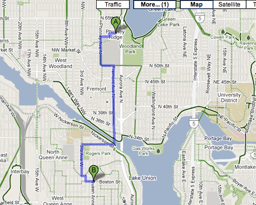
In the case of getting from home to Queen Anne Ave. N., a nasty hill from any direction, Google gave a “least painful” option up 3rd Ave. N. from Nickerson. But this time it chose the more circuitous route. To be fair, the way I take is for an experienced cyclist — down Aurora, across the bridge and turn right at the south end of the bridge for a short ride to Queen Anne Ave. You can also ride up Dexter on its bike path from Fremont and cut under the Aurora Bridge, but that’s also a bit more challenging (albeit shorter).
You get the drift here. If you’re bike savvy, you probably will use “Bike There” largely as a second opinion — unless you haven’t been to your destination before or are generally unfamiliar with the layout of a place.
But for the general public, “Bike There” is a terrific service and huge step forward in encouraging folks to get out ‘n ride. The Google announcement made the point that “Bike There” helps persuade the public that bikes belong on any street or thoroughfare, and deserve to be included in any directional matrix.
Undoubtedly similar applications are destined for the iPhone and wireless devices for on-the-fly GPS. But Google has definitely done its homework. We’ll be pounding on “Bike There” more in coming weeks and do a followup report. But we doubt we’ll find much to complain about.
BikeHugger takes a look at Bike There’s reach.
Another minor quibble — in addition to a “hill tolerance” selector, it needs a “trail surface” selector. Generating bike directions from my house near Duvall to the MS campus suggests a route along the Tolt Pipeline Trail. It’s a fun ride, but it’s dirt/gravel, VERY hilly, and not something I would do as part of a typical commute.
That said, I’m very excited about this. Not bad for a feature that’s been available publicly for less than 24 hours :).
Re: seeing hills.
You can turn on the “terrain” option while viewing the “bicycling” option. 😉